by Maurice Y. Michaud (he/him)
Background reading
- 2022 Saskatchewan Constituency Boundaries Commission, Final Report
.
- Wikipedia: Saskatchewan
 Although sizeable in terms of territory, Saskatchewan is a small province in terms of population. Covering nearly 652,000 square kilometres, its population reached about one million in the 1990s and stands at about 1.23 million in 2024. While it is claimed that two-thirds of the population lived in urban areas by 2005, those centres are still relatively small today. About 40 percent of the province’s population lives in either Saskatoon (264,000) or Regina (224,000), while 8 percent lives in Prince Albert (37,000), Moose Jaw (33,000) or Lloydminster (31,000). The remaining “urban” population is distributed over 59 towns and villages, with Swift Current and Yorkton at the top of that list with about 16,000 each, and Caronport last with barely 1,000. As discussed elsewhere, this steady but slowing growth compared to the early years of the 20th century (and currently compared to some other provinces) has already and can still present challenges in determining of the number of federal seats the province should have.
The overwhelming majority of Saskatchewan’s population is concentrated in the prairies found in the southern third of the province, roughly south of the 53rd parallel. However, and particularly for the purpose of drawing the electoral map, the province is split more or less in half by what is called the “Northern Administrative District Dividing Line.” The northern half contains only two ridings, which are protected — Athabaska and Cumberland — and redistribution is applied only to the southern half.
As shown in the sidebar on the right, for general elections from 1917 to 1964, Saskatchewan used the plurality-at-large (or “block”) electoral system in Saskatoon, Regina and Moose Jaw, and the first-past-the-post system everywhere else. But from 1905 to 1917, and since the 1967 general election, all ridings are single-member and each member is elected by FPTP.
In addition to excluding the population north of the dividing line (PN), Saskatchewan also makes a point, when calculating the electoral quotient (formally called the “Constituency Population Quotient,” or CPQ), of defining “Population” (P) as including only persons aged 18 years or older. This distinction does not seem to be made in other jurisdictions at this stage, although each jurisdiction separates eligible voters from the overall population, but this approach has the virtue of accounting for areas with much younger demographics. Meanwhile, since the number of southern seats had just been raised to 59 at the previous redistribution, that number was to be used again in 2022 as the denominator.
The sidebar also shows that, before the Constituency Boundaries Act of 1993, the number of seats (or S) had peaked at 66 in the 22nd legislature formed in 1991. The Act brought that number down to 58. It stayed there for nearly two decades, rising by three in the 2012 redistribution which resulted in the map used in the 2016 and 2020 general elections.
So, the value of S having already been determined, when Statistics Canada finally released its breakdown by age groups in late-April 2022, the formula:
The Act of 1993 allows a variance of ±5% among the southern ridings. However, when the commissioners looked at those 59 ridings as they were constituted a decade earlier, they found that only 13 were still within that variance. In fact, Regina and Saskatoon each had two ridings that were severely overpopulated in comparison to the new electoral quotient:
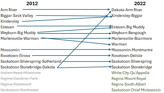
So what happened to those four overpopulated ridings, you ask?
Setting aside the ridings that haven’t been abolished — although their boundaries have certainly changed — we find that the 2022 redistribution has led to some localities being merged into other ridings, with a few place names being dropped from or added to the map.